Last reviewed
Background
Northern Xinjiang where the Altai ranges meet the Irtysh basin.
Altay Prefecture occupies China’s far northwest, where forested Altai slopes, glacial rivers and broad steppe feed the Irtysh system. Burqin is the usual gateway to Kanas, while the lake, river bays and mountain villages form a dispersed landscape that requires patient travel rather than a quick city break.
Hemu and Baihaba are living settlements associated especially with Kazakh and Tuvan communities, not open-air sets. Tourism has changed their built environment and economy, but homes, herding routes and religious or family life still deserve privacy. Ask before photographing people, respect livestock and use designated visitor paths.
Recommended itineraries
Recommended itineraries
Keep transfers realistic: Kanas, Hemu and Baihaba may look close on a map, but managed access, mountain roads and weather make each move slower.
Burqin, Kanas and Hemu
A compact first route connecting the Irtysh-side gateway with the best-known lake and village landscapes.
- Day 1 · Arrive in Burqin and visit Colorful Beach only if weather, daylight and current access make the detour worthwhile.
- Day 2 · Transfer into the Kanas area, then walk selected river-bay viewpoints without attempting every platform in one afternoon.
- Day 3 · Spend the clearest part of the day around Kanas Lake and Guanyu Pavilion, adjusting the order for cloud, wind and managed transport.
- Day 4 · Continue to Hemu for village paths and nearby viewpoints, staying overnight if your onward schedule allows.
Kanas and the mountain villages
A slower circuit that gives Baihaba and Hemu enough time to feel like places rather than brief photo stops.
- Day 1 · Reach Burqin and prepare for the mountain section, confirming current entry and transport arrangements.
- Day 2 · Travel to Baihaba and walk only public village lanes and marked landscape routes.
- Day 3 · Continue to Kanas, using the afternoon for Wolong, Moon and Shenxian bays according to conditions.
- Day 4 · Explore Kanas Lake and the main high viewpoint, retaining a low-level alternative for poor visibility.
- Day 5 · Finish in Hemu with an unhurried village walk before the long onward transfer.
Koktokay and Fuyun
A separate eastern Altay route for travelers interested in Irtysh headwaters, canyon geology and Koktokay’s mining-town history.
- Day 1 · Reach Fuyun or Koktokay and use the town or museum interpretation to understand the landscape before entering the scenic area.
- Day 2 · Follow one managed route through the Irtysh Grand Canyon and related Koktokay landscapes, checking weather and park operations before the long onward transfer.
Attractions & practical tips
What to see—and how to approach it.
Colorful Beach
五彩滩
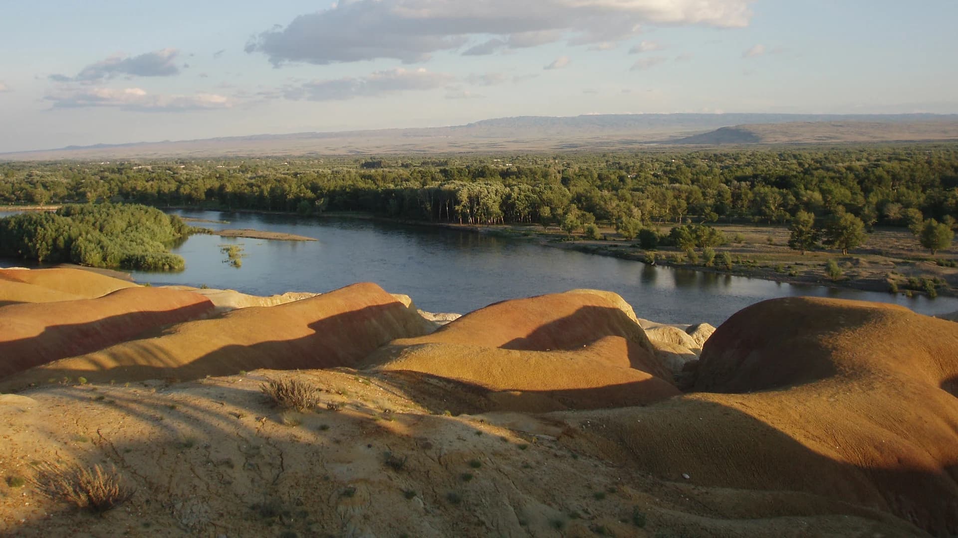
Wind- and water-eroded rock layers line the northern bank of the Irtysh near Burqin, with red, ochre and pale tones contrasting against river vegetation.
Practical tips
- Low-angle light can strengthen the colors, but wind, cloud and haze matter more than a fixed visit time.
- Stay on constructed paths because the soft formations erode easily and exposed edges can be unsafe.
Kanas Lake
喀纳斯湖
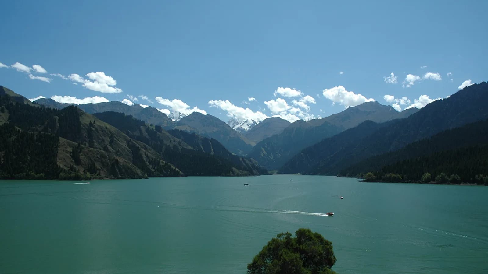
A long alpine lake fed by glaciers and rain in the Altai, enclosed by forested slopes whose color and visibility change sharply with season and weather.
Practical tips
- Plan around current managed transport and walking routes rather than old ticket, shuttle or opening information.
- Carry warm and rain-resistant layers even in summer, and do not enter restricted water or forest areas.
Wolong Bay
卧龙湾
A broad bend in the Kanas River where wooded banks and a distinctive vegetated river island create a layered valley view.
Practical tips
- Use the marked viewing route and judge any longer walk by current trail conditions.
- Morning frost, rain or fallen leaves can make stairs and boardwalks slippery.
Moon Bay
月亮湾
The Kanas River curves through forest in a crescent-shaped reach, one of the area’s clearest examples of water shaping the valley floor.
Practical tips
- A high viewpoint explains the river form better than rushing directly to the lowest boardwalk.
- Expect crowding at narrow platforms and keep circulation clear while taking photographs.
Shenxian Bay
神仙湾
A wider wetland reach of the Kanas River known for calm water, meadow, forest reflections and occasional morning mist.
Practical tips
- Mist is weather-dependent, so treat it as a possibility rather than a guaranteed sunrise effect.
- Remain on visitor routes to protect wet ground and avoid disturbing grazing animals.
Guanyu Pavilion
观鱼台
A high observation point above Kanas Lake that reveals the lake’s full length, enclosing ridges and the scale of the glacial valley.
Practical tips
- Choose it only when visibility and current access justify the climb or managed transfer.
- Allow for altitude, stairs and fast weather changes; turn back if wind or storms make the exposed route unsafe.
Hemu Village
禾木村
A mountain settlement in a broad river valley, known for timber buildings, surrounding birch forest and a pastoral landscape that remains home and workplace for local residents.
Practical tips
- Ask before photographing residents, homes or livestock, and avoid blocking lanes for posed images.
- Use marked public viewpoints and confirm current local transport because private vehicle access may be controlled.
Baihaba Village
白哈巴村
A small settlement near the international border where timber homes, forest and grassland sit beneath the western Altai.
Practical tips
- Border-area entry requirements can change; verify current documents and permitted routes before departure.
- Respect homes and working pasture, and never use drones or leave marked areas without explicit authorization.
Koktokay Scenic Area
可可托海景区
A large protected landscape in Fuyun County combining the Irtysh Grand Canyon, Koksuli wetland, Irem Lake and evidence of the region’s geological and mining history.
Practical tips
- Koktokay is far from Kanas, so plan it as a separate eastern Altay route rather than combining both in one compressed day.
- Use current managed transport and trails, carry layers for exposed mountain weather and stay out of closed mining or conservation zones.
Food & dining
Eat with a little local context.
Altay food reflects cold-water rivers, pastoral dairy traditions and familiar Xinjiang staples. Availability changes by village and season, so use these dishes as a guide rather than a checklist.
Grilled pike
布尔津烤狗鱼
Freshwater pike from the Irtysh system is grilled until the flesh is firm and the skin lightly charred, especially around Burqin.
Try it this way: Ask about bones and portion size, and choose a busy, hygienic kitchen that cooks the fish thoroughly.
Kvass
格瓦斯
A lightly fermented bread drink with a sweet, malty flavor, commonly encountered in northern Xinjiang.
Try it this way: Fermentation and sweetness vary; check the label if you avoid trace alcohol or added sugar.
Milk curds
奶疙瘩
Firm dried dairy curds preserve milk in a portable form and range from sharply sour and salty to comparatively mild.
Try it this way: Start with a small piece because the concentrated flavor and texture can be intense.
Kanas apples
喀纳斯苹果
Small local apples provide a crisp, tart counterpoint to the region’s richer meat and dairy dishes when in season.
Try it this way: Buy washed fruit from a regular shop or market and do not pick from private orchards.
Xinjiang pilaf
抓饭
Rice cooked with carrots, onion and meat is a filling regional staple suited to long travel days.
Try it this way: Ask about serving times because specialist kitchens may prepare a limited batch earlier in the day.
FAQ
Questions worth answering before you go.
How many days do I need for Kanas, Hemu and Baihaba?
Four days can cover Burqin, Kanas and Hemu with careful transfers. Allow five days if Baihaba matters, and add more buffer when arriving overland from Urumqi because northern Xinjiang distances are substantial.
When should I visit Altay Prefecture?
Summer supports greener trails and longer daylight, while early autumn can bring strong forest color and much colder nights. Snow, rain, wind and seasonal access vary, so verify short-range conditions instead of relying on historic calendar claims.
Can I treat the Kanas area as a quick day trip?
No. Burqin, Kanas, Hemu and Baihaba involve long road transfers plus managed local transport. Stay within the area, keep one major landscape focus per day and avoid scheduling a fixed flight or train immediately after a mountain transfer.
How should I behave in Hemu and Baihaba?
Remember that the villages are homes and workplaces. Ask before photographing people or private property, keep away from livestock, follow guesthouse rules, limit noise and never assume a resident’s culture exists for visitor entertainment.
Do I need to verify hiking or border-area access?
Yes. Trail, vehicle and border-area rules can change, especially around Baihaba and remote mountain routes. Use current official information, carry the documents requested and do not follow old advice about informal crossings, camping or unmarked hikes.